
Geospatial Imaging Market
Report ID: UCMIG45A2115
SkyQuest Technology's Geospatial imaging market size, share and forecast Report is based on the analysis of market data and Industry trends impacting the global Geospatial Imaging Market and the revenue of top companies operating in it. Market Size Data and Statistics are based on the comprehensive research by our Team of Analysts and Industry experts.
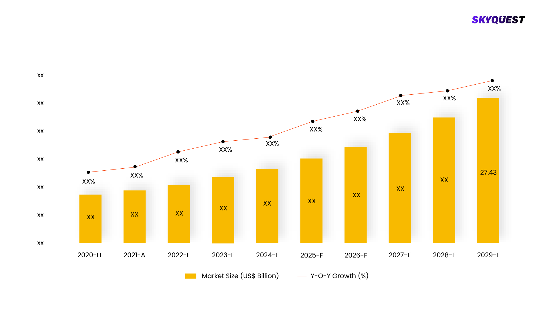
The global market for geospatial imaging, which involves capturing, analyzing, and interpreting Earth's surface imagery and data, had a value of USD 1.73 billion in 2022. It is expected to experience significant growth, reaching USD 2.02 billion in 2023 and ultimately reaching USD 5.84 billion by 2030, with a projected compound annual growth rate (CAGR) of 16.4% during the forecast period. Geospatial imaging employs various technologies like mobile mapping systems, aerial photography, LiDAR, and remote sensing and finds applications in industries such as infrastructure, environmental monitoring, exploration, transportation & logistics, among others.
This report is being written to illustrate the market opportunity by region and by segments, indicating opportunity areas for the vendors to tap upon. To estimate the opportunity, it was very important to understand the current market scenario and the way it will grow in future.
Production and consumption patterns are being carefully compared to forecast the market. Other factors considered to forecast the market are the growth of the adjacent market, revenue growth of the key market vendors, scenario-based analysis, and market segment growth.
The market size was determined by estimating the market through a top-down and bottom-up approach, which was further validated with industry interviews. Considering the nature of the market we derived the Internet Software & Services by segment aggregation, the contribution of the Internet Software & Services in Software & Services and vendor share.
To determine the growth of the market factors such as drivers, trends, restraints, and opportunities were identified, and the impact of these factors was analyzed to determine the market growth. To understand the market growth in detail, we have analyzed the year-on-year growth of the market. Also, historic growth rates were compared to determine growth patterns.
REQUEST FOR SAMPLE
Want to customize this report? This report can be personalized according to your needs. Our analysts and industry experts will work directly with you to understand your requirements and provide you with customized data in a short amount of time. We offer $1000 worth of FREE customization at the time of purchase.
Feedback From Our Clients
Report ID: UCMIG45A2115
sales@skyquestt.com
USA +1 351-333-4748
 USA (+1) 351-333-4748
